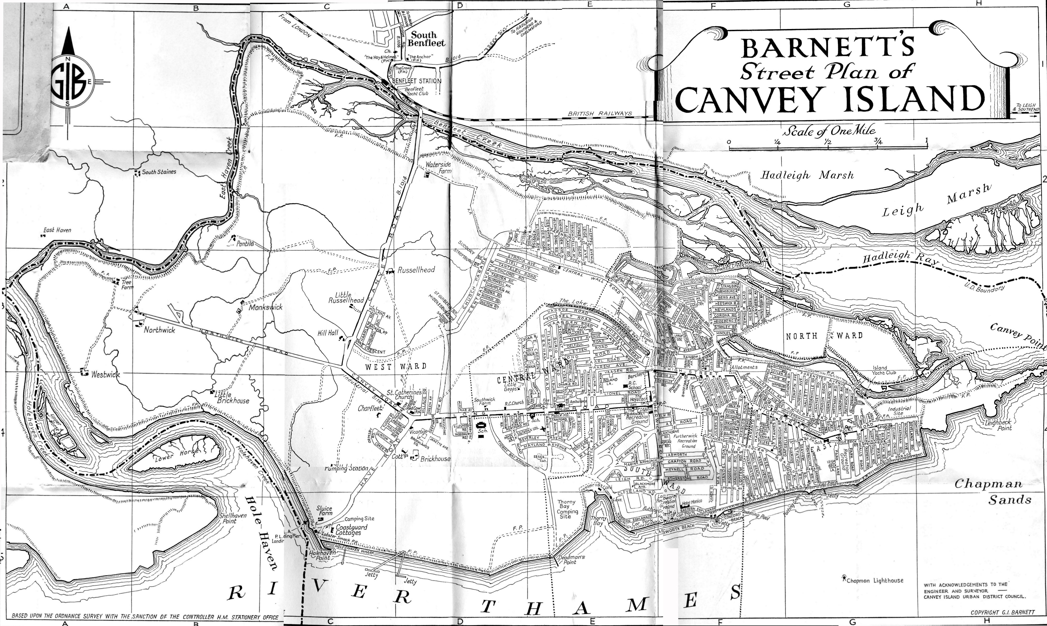
This is an excellent detailed road map Janet and covers the period that I spent on Canvey,1941-1953. I’m sure that more memories will emerge as I go over the enlarged sections, and while with the North thames Gas Board I got to travel most of the roads and worked in many of the homes.
By Gerald Hudson (27/02/2013)
Do you know what date this is Janet? I didn’t think Nat. West Bank came to Canvey until the sixties or seventies. Cooks Farm over Winter Gardens isn’t shown on the map either.
By Maureen Buckmaster (01/03/2013)
No Maureen it does not give a date but I am pretty sure it is around 1950
By Janet Penn (01/03/2013)
An interesting map and as to date. I thought the dam shown was installed after the 1953 flood, anyone confirm this? Interestingly Smallgains Avenue is called Forensted on this map. I have a Stephen James estate agent map circa 1969 and it was certainly called Smallgains Avenue then. The creek was clearly shown with a dam then and a private road alongside to the refuse site (now Canvey Heights). Although not shown near the lake shown on the map was Canada Corner, but that was swallowed up when the tip was extended. There were native Canadian trees there. The trees in the Paddocks and a commemorative stone now replace it. Now hundreds of people pass it every week going to the health centre or to park and I doubt if they even know it is there.
By John T Pharro (14/08/2021)
Unfortunately John maps are very hard to date. In this map the King Canute was called the Red Cow. Which would suggest 1953 or earlier. Maps get tweaked.


Comments about this page
This is an excellent detailed road map Janet and covers the period that I spent on Canvey,1941-1953. I’m sure that more memories will emerge as I go over the enlarged sections, and while with the North thames Gas Board I got to travel most of the roads and worked in many of the homes.
Do you know what date this is Janet? I didn’t think Nat. West Bank came to Canvey until the sixties or seventies. Cooks Farm over Winter Gardens isn’t shown on the map either.
No Maureen it does not give a date but I am pretty sure it is around 1950
An interesting map and as to date. I thought the dam shown was installed after the 1953 flood, anyone confirm this? Interestingly Smallgains Avenue is called Forensted on this map. I have a Stephen James estate agent map circa 1969 and it was certainly called Smallgains Avenue then. The creek was clearly shown with a dam then and a private road alongside to the refuse site (now Canvey Heights). Although not shown near the lake shown on the map was Canada Corner, but that was swallowed up when the tip was extended. There were native Canadian trees there. The trees in the Paddocks and a commemorative stone now replace it. Now hundreds of people pass it every week going to the health centre or to park and I doubt if they even know it is there.
Unfortunately John maps are very hard to date. In this map the King Canute was called the Red Cow. Which would suggest 1953 or earlier. Maps get tweaked.
Add a comment about this page